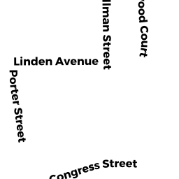
12 PORTER ST
Owner Information
MORRISSEY KARELLE A
12 PORTER ST
BEVERLY, MA 01915


Property Details
12 PORTER ST is classified as a Single Family Residential (Ranch).
The primary structure on this property was built in 1918. There are 1,208ft2 of built area within this property. There is 1,208ft2 of residential/living space within this property. This property is listed as having 4 rooms.
12 PORTER ST is valued at $436,000. The land is valued at $245,900 and the structures are valued at $190,100.
This property is in Zone R6. Confirm with local Zoning Board authorities to ensure there are no overlays or other easements on this property.
The most recent deed for 12 PORTER ST is recorded at the local registrar in Book 37063, Page 426. 12 PORTER ST was last sold on Thursday, October 4, 2018 for $1.
Assessment data from fiscal year 2022.
Flood Data
According to the FEMA National Flood Hazard Layer, this property does not appear to be in a flood zone. It may also be in an area not yet reviewed. Nonetheless, confirm this information prior to taking any action.
To view the flood hazards around this property, create a FEMA "Firmette" Map of the area around 12 PORTER ST.
Broadband Internet Providers
| Provider | Type | Bandwidth (mbps) | |
|---|---|---|---|
| Viasat Inc | Satellite | 100 | 3 |
| Comcast | Cable | 1000 | 35 |
| Verizon New England Inc. | DSL | 10 | 1 |
| VSAT Systems, LLC. | Satellite | 2 | 1 |
| HughesNet | Satellite | 25 | 3 |
| GCI Communication Corp. | Satellite | 0 | 0 |
Broadband service provider data from December 2020.
Adjacent Properties
- 8 -10 PORTER ST
Apartments with Four to Eight Units owned by HARBORVIEW-PORTER REALTY TR - 16 PORTER ST
Two-Family Residential owned by BIXBEE BRIAN - 11 AGATE ST
Two-Family Residential owned by ELSO ADRIENNE J - 13 AGATE ST
Two-Family Residential owned by 13 AGATE STREET REALTY TRUST - 15 AGATE ST
Single Family Residential owned by TURGEON BRIAN